Showing posts with label river. Show all posts

The soft edge


Soft edge is defined as strips of waterfront land occupied by bushes consist of trees and thick understorey. The area can be either untouched natural forest or disturbed landscape (replanted backyard area of village houses or naturally regrown, occasionally with weeds). In Kuching's context, it is part natural landscape, part cultural landscape. Seen from the river it is a beautiful landscape. From the land, villagers can get glimpses of the modern city along the opposite bank through framed views.

This strip of meandering landscape, visible from the urban area of the southern side it seems like a thick bold line drawn between the water and the land. It is a beautiful gesture that forms the most beautiful natural setting Kuching city possess for centuries, while on the south bank the city developed and urbanised over the last hundred years.

See how this beautiful landscape of Kuching being captured by photographers:
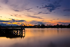

Kuching, Sarawak (Borneo), East Malaysia - Kuching Waterfront Pier ~ Sunset
Originally uploaded by YYZDez
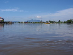


Sunny Day At Sarawak River
Originally uploaded by thienzieyung


Once Upon A Time In Kuching
Originally uploaded by onggon ~ im back
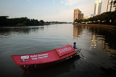


Perahu Tambang
Originally uploaded by Roslan Tangah (aka Rasso)


Aerial map below shows the existing soft edge along the Sarawak River. You can see the soft edge along the northern bank is almost unbroken continuously running as far as your eyes can see, perhaps the full length of the river from the river mouth to the upper tributaries where the jungles and mountains are. At the city the line is only punctuated at jetties and most obvious at the Astana where the clearing allows un-disrupt views from the Governor's residence

Over the last few years there are changes along the edge opposite the city centre. I noticed the first change during my last visit in 2006 and it was recorded as the following shot. On the map the effected areas are marked in blue lines.

Published at around same time, the Sarawak Sketch also documented the changes. As below

Sarawak sketchbook, Illustrations by A. Kasim Abas ; text by Peter Kedit

"The north bank of Kuching in the late 19th Century. Malay villages surrounded by orchards and small gardens nestled under the shelter of the fort. One hundred years later, some of the idyllic village scenes have made way for riverside improvements. The administrative buildings of Sarawak now dominate the skyline. One thing, however, has not changed : the 'sampan' of ferries, still carry much of the cross-river traffic."

The lines marked as red on the map below indicate the most important stretch of the soft edge that contributes to the unique image of the city but it is in danger of being vanished forever. The line marked as purple shown the fast disappearing section of soft edge due to the development of the State Assembly Building. See related post and link of the developments. See pics below for the extent of clearing at the moment:
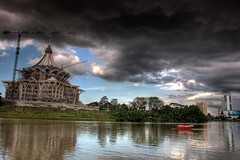

Dark Force Approaching
Originally uploaded by Jieja
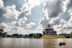


Sarawak Reggata 2008 #03
Originally uploaded by
Roslan Tangah (aka Rasso)


I must stress that the soft edge is an important asset to Kuching and any city and town dotted in Borneo island as well as South East Asia. It truly represents the unique image of this region.

However, the actual condition of the soft edge may not be in line with the picturesque quality seen from the river, it shouldn't be perceived as a bad unwanted place - just a stretch of unused land along the river edge infested with weeds, or in the poor state of maintenance or cleanliness; or even dumping ground for garbage.

There isn't any field study of the soft edge. It is hope that this post will stimulate interest to specialist groups such as ecologists and environmental planners.

In the developed and fast developing cities around the world, most of the waterfront edge along the urban area has been concreted or rebuilt into marina hence destroying the character of the city. The homogeneity of cities is a common mistake Kuching city must avoid. Read related news article 'Cement wall destroying Spain's coast' posted on November 25, 2008


Kuching - tourism perspective #1

Below are some of the phrases taken from "The official Kuching guide 2007" prepared by Wayne Tarman & Mike Reed, sponsored by Sarawak Tourism Board.

"Like all towns and cities in Borneo, the focal point of Kuching, and the reason for its existence, is the river. Hiring a “sampan” to meander slowly up and down the Sarawak River is the best way to get your first impression of Kuching, and a real bargain. It’s good during the day, bliss at sunset and a truly one-off experience at night. From the river you will see picturesque Malay villages (kampungs), a golden-domed mosque, a Victorian fort, a whole street of 19th century Chinese shophouses and an imposing wooden-roofed palace, all set against a background of distant mountains."

"The Waterfront offers excellent views of the Astana, Fort Margherita and the Malay kampungs which line the north bank of the river, but at night-time it really comes alive; it seems like half of Kuching is out meeting friends, watching a show, or just taking the air. "

Obviously, the quality of the city can be summed up as follow:
  • the villages (kampung) line the north bank of the river, opposite the city centre.
  • the river as the primary icon of the city
  • waterway transport - the sampan (small wooden boat)
  • picturesque setting made up from these features - distant mountains, historic buildings, villages, sunset and the river.
So the question I want everyone to ask is the modern development as shown in this post - the oversized State Assembly building, arced pedestrian bridge and wide boulevards to replace the forested water edge, villages and the surrounds of the historic sites appropriate ?

Kuching Waterfront and the old markets

Photos show views from the same location - the eastern end of the Ceko old market overlooking
river edges of the Sarawak River. The southern edge (left of photo) is lined with market's buildings, dockyards. Fishing boats unload catches here at the loading docks (shown on second and third photo below). Sampan (small boat shown on the first photo) bring village residents from the northern side of the river to shop at the old markets everyday. Life like this has been going on for nearly a century.

"The wet markets are strategically sited. Boats bringing in produce can unload their goods at the back, while housewives on a shopping expedition approach the airy hall from the road." Quote from Sarawak sketchbook

Check this link to see the proposed plan to turn this stretch of waterfront into another modern leisure paradise which can be anywhere in the world. In other words, is this development necessary ? in the expense of one unique feature of the city? and also erasing city-working river relationship?

See post Kuching old Ceko Market


Kuching Waterfront 2
At Flickr by SamCotton

Photo by Desmond Ong

Photo by Desmond Ong

Crossing The River

Crossing Sarawak's Limbang River. Although this photo is not taken along Sarawak River or anywhere near Kuching, it does represent a typical way of life many Sarawakan live along the river. The houses scattered along the river edge are similar to those villages opposite Kuching city.

So similarly you can see many villagers make daily trips by sampan (wooden boat) to Kuching old markets in the downtown to shop of fresh produces and other groceries.

The following photo - 'sampan' was taken from the old market, view to the villages lined along the opposite bank of the Sarawak River.


Kuching River Edge

Quality of the river edges still visible from Kuching CBD. The DUN (State Assembly Building) grand plan will drastically change the edges forever.

See links below to see individual photo uploaded at Flickr:
1. Sarawak river ferry, 2. Kuching, 3. Kuching Waterfront 1, 4. Kuching Waterfront 2

State Assembly Building at the river front #1

The DUN - Dewan Undangan Negeri (State Legislative Assembly building). The bulk size of this building will dominant the skyline of Kuching city. It is built on the site where originally covered with thick vegetation prominently forms the unique image of Kuching. Now with the clearing had been done to the water edge, you can see the beginning of urbanising the other side of the river.

River city study - Luang Prabang, Laos


Luang Prabang - "A royal gem, reclining against the mountains and dangling its feet in the river" "Luang Prabang, made a Unesco World Heritage city for both its beautiful buildings and the serenity of its natural surrounds, has become Lao PDR's foremost tourist showpiece" Lonely Planet.

Luang Prabang, a Laos city with current population of 103,000

No other river city in the world has this unique character like Luang Prabang. Nature is the dominant feature. It covers much of the city center and the whole stretch of the riverbank. This portrays image of Laos to the outside world that this country still live in the old world. Timeless and untouched by the modernity.

Urban centre is well integrated with the landscape

Has impressive historic buildings without being imposing but blend well with the existing landscape

Like Kuching, Luang Prabang has good blend of well preserved colonial buildings and local architecture, set against rivers and mountains of beautiful natural beauty, which led to Luang Prabang designation as a World Heritage site in 1995. As the result of such an early recognition before the country's opening to outside world has effectively protected the old city and its beautiful surrounds from the ravages of hasty development.


http://en.wikipedia.org/wiki/Luang_Prabang

Kuching riverfront view from the hotel [1]


Original photo is posted at Flickr. This is one of the most important shot found. It shows the typical view from hotel room facing the Sarawak river (north to north western view) (map and views diagram coming soon). Taken on a sunny day the context are clearly visible. The owner of this photo and also the proceeding shot had made a comment about her preference of the trees area on the opposite bank remains untouched. The current condition shows the new nearly completed building - the Assembly Building is actually changing the quality of the existing aspect forever.


blogger templates |